
Brochures
|
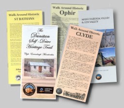
Download pdf (5meg) |
|
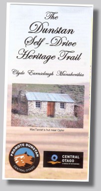
Introduction This brochure is a guide to a self-drive trip from Clyde, through the manuherikia Valley to St Bathans and back, optionally returning via the Ida Valley. The drive is 176km in length and in intended to take something in excess of four hours. Allow an extra hour if you take in the Ida Valley. Along the way you will visit many sites of historical importance. It is an area rich in the early European history of New Zealand. There are several excellent places to stop for refreshments including the Chatto Creek Tavern and the Vulcan Hotel in St Bathans. The area known as The Dunstan stretches from Clyde into the Manuherikia Valley and was one of New Zealand’s richest gold fields. It was visited by Maori, who camped by rivers in summer and the earliest European settlers were sheep farmers whose runs extended over thousands of hectares. The discovery of gold at Lawrence in 1861 heralded a huge rush as more fields, yielding enormous quantities of gold, were found throughout Central Otago. Thousands of miners were lured here despite the extremely harsh climate and environment. Many stayed to establish permanent townships on the sites of calico (cloth) settlements. The remains of those places and the scars left by mining operations still can be seen. Clyde, Ophir, and St Bathans are the most authentically preserved and significant gold rush settlements in New Zealand; little remains of many other settlements apart from their names and some ruins. Others have survived with a few permanent residents and old cottages now used as holiday homes. Some old buildings have become part of local farms. Gold prospectors and mining companies still search for gold in the district. |
 |
|
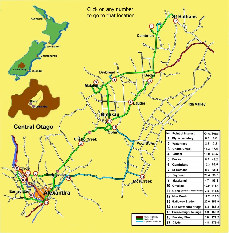
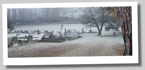
Dist : 0.0km Total 0.0 km The old cemetery is bound by walls and entry pillars of local stone and wrought iron gates. It contains the remains of many notable early settlers and gold miners from throughout the Dunstan. The earliest graves date from the 1850’s. More details can be found in the Clyde Cemetery brochure available from Clyde’s museum. A little further along the road on the right is Young Lane where Central Otago’s first winemaker, Jean Desire Feraud built a stone winery. It is privately owned and cannot be seen from the road. More information on Feraud can be found in Central Stories Museum in Alexandra. |
 |
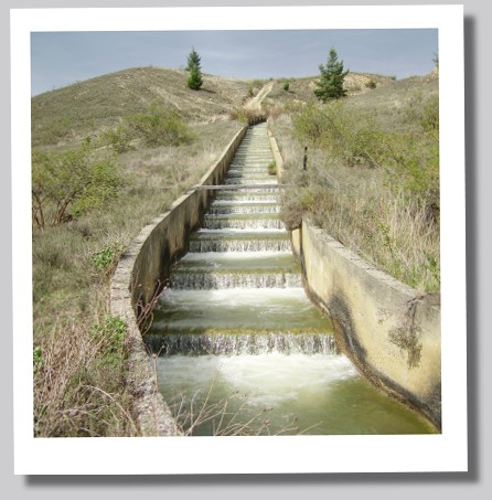 |
Dist 2.2 km Total 2.2 km This unusual race has concrete steps rather than a pipe which was a more expensive method of lowering the water. It was built in the 1930’s when most of the extensive irrigation networks and major dams in the region were constructed and the Great Depression ensured there was no shortage of labour. Old gold mining races resting on stone walls can be seen winding around hillsides and some are still used to irrigate farm land. Because of the very low rainfall here, nothing will grow without irrigation. At 6 k turn left onto Highway 85. |
|
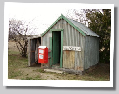
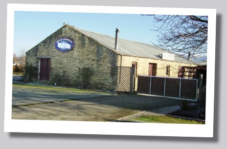
Dist 15.3k Total 17.5km The origin of the name has been lost. The Chatto Creek Tavern was built in 1886 of mud bricks and stacked stone and contains historical photographs and memorabilia. Numerous Chinese gold miners worked in this area and a large gold dredge operated nearby. The original Chatto Creek post office (was a tent plastered with newspapers for insulation which) opened in January 1896. It was replaced by a public works hut in 1933 and closed in 1975. The hut was shifted to Alexandra but was brought back to Chatto Creek by the local Restoration Committee in 2004. |
 |
 |
Dist 18km Total 35.5km On the left is an example of an early stone house and a little further on is Lauder Cottage built of mud-brick, a readily available building material and familiar to early settlers from Scotland. Many of Central Otago’s historic buildings are mud-brick. |
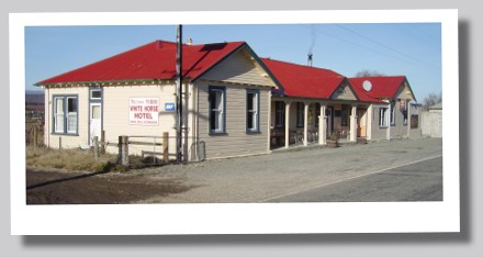
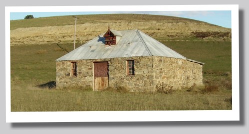
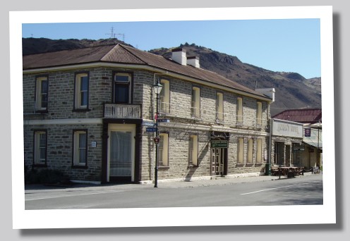
5. BECKSDist 8.7km Total 44.2km Originally the village was called White Horse but became known as Becks after a prominent early settler, John Beck. Just over the bridge on the left are the corrugated iron remains of the blacksmith’s forge, a mud brick shed and a large stone step of a house. Further along is the Old White Horse Hotel an important New Zealand historical building. Built by Beck in 1864, it is one of the ten oldest hotels or former hotels in New Zealand registered by the New Zealand Historic Places Trust. It served many purposes becoming a depot for collection for rabbits in 1898 when there was a huge rabbit trapping industry, a post office and later the telephone exchange and was turned into a shop. That closed in 1958 and the building was left to decay. It was saved after nine locals who met in 1990 and formed the Old White Horse Hotel Historical Association which is gradually restoring the building. Please respect the historic fabric of the building when viewing. Call into the new White Horse Hotel (1925!) on the right for further information. Continue for 0.6km and turn left onto the St Bathans Loop road. Pause 200 m on the left to view old mud brick and stone farm buildings. A little further on the left is the original homestead and workers’ cottages. |
 |
|
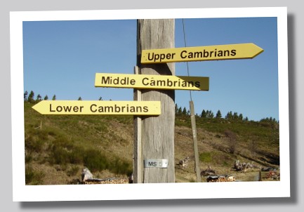
Dist 12.3km Total 56.5km As the name suggests it was settled by Welsh miners in 1863 who worked the gold and coal diggings there. The rivalry and sometimes bitter acrimony between the Protestant Welsh and their Catholic Irish counterparts in nearby St Bathans was known as the “War of the Roses. Cambrian has a number of quaint early cottages and we ask you to respect the privacy of the occupants.
|
 |
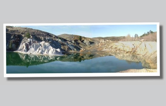 |
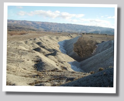
Dist 8.6km Total 65.1km Entering St Bathans on the left is a spectacular moonscape-like terrain which was created by heavy sluicing after gold was discovered in 1863. There were three large mining operations one of which later formed the famed Blue Lake. Just under 3 thousand kilos of gold came from St Bathan’s but when it dwindled so did the town. Today there are few permanent residents and there is a rich history to be explored. Park opposite the pub and explore on foot. More details can be found in the “Walk Around St Bathans” brochure.
|
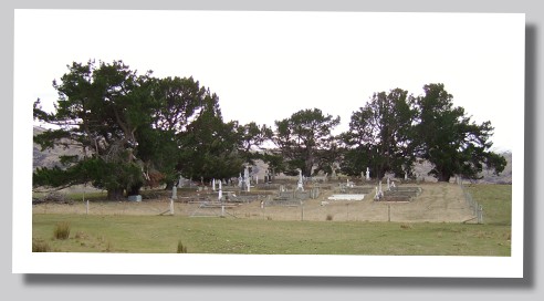 |
Dist 28.4km Total 93.5km The legend goes that the name Drybread came after a wary prospector, when asked how he was doing, replied “dry bread, seldom better”. Few buildings remain but those that have survived, including the Drybread Hotel (on the right) are now used as farm buildings. A little further on is the signpost to the Drybread cemetery which contains many early graves. Turn right and follow the track for 1.2km (dry weather only) Return to the sealed road. Continue for 4.7 K to Naylor road and follow the loop around : |
|
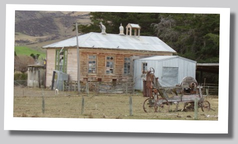
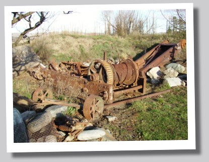
Dist 4.7km Total 98.2km It lies at the foothills of the Dunstan Mountains and was known as Tinkers, a name possibly derived from the tinsmiths (known as tinkers) who it is said, abandoned their trade of repairing pots and pans and instead, used them for washing gold. Another explanation is that when miners were asked how they were doing, they responded: “Just tinkering about”. On the left is the original school; its rooftop bell tower, a rare sight. The settlement has a number of mud brick buildings in various states of disrepair. The former Newtown Hotel was rebuilt using the old stone walls of the original. Opposite is a mud-brick store that originally began life as a goldfields dancehall. Behind are the stables. A water sluicer lies by the start of Sugarpot road (along which lies the now flooded head of the Deep Lead mine whose shaft was sunk nearly 80 metres in about 1898.) Follow the loop road where old diggings can be seen on the hills. Continue on through Matakanui, following the loop road (Naylor Road) around. Drive back to the sealed road and turn right into Racecourse Road, following this to Omakau. |
 |
 |
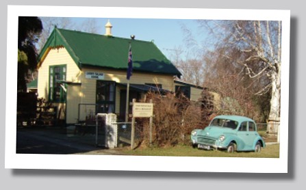
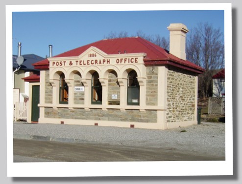
Dist 12.9km Total 111.1km Once a small farming centre, its growth was hastened when the railway line reached it in 1906. To visit the cemetery, turn left off Racecourse road,(at the school), into Deaker street. Continue along the main street to the Commercial Hotel on the right. This much altered building was built by the Leask family in about 1898 as a farmhouse. It then became a boarding house and finally a hotel. Alongside are magnificient stone stables built about 1880. If you intend taking the optional route (see below) turn right onto Highway 85. At 1.9K turn left at the signpost to Ophir and cross the Manuherikia River over the picturesque suspension bridge named for the Irish patriot, Daniel O’Connor. If you chose not to take the optional route, cross the bridge in Omakau (signposted Ida Valley and drive 2 k to Ophir on the right. |
|
Dist 3.5km Total 114.6km Ophir was originally known as Blacks Diggings, then just Blacks when gold was found in 1863 on the property of local runholder, Charles Black. In 1875 the name was changed to Ophir, the biblical name of the gold mine where the Queen of Sheba obtained gold for King Solomon. A separate brochure, “Walk Around Historic Ophir” will guide you around the village. Cross the historic bridge (see above) and continue to Alexandra. (see below) |
 |
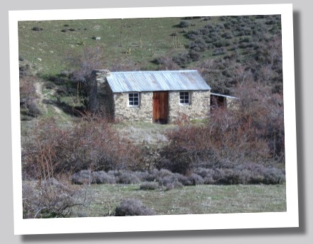
ALTERNATIVE ROUTE (Partly unsealed) Turn right by Blacks Hotel in Ophir by sign to Ida Valley. At 1km on the right, pause to view McTavish’s Hut, a restored miner’s hut. The road climbs Blacks Hill over the Raggedy Range then drops into the vast Ida Valley. At the foot of the range is Poolburn. Turn right at the hotel onto the Poolburn-Moa Creek road. |
 |
 |
Dist 17.7km Total 132.3km This settlement, now just a few houses, sprang up after the discovery of gold in 1863.
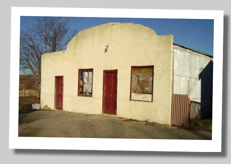
The two buildings on the right date from the late nineteenth century. The larger was the Moa Creek Hotel built in 1912 which replaced the “Carriers Arms” built in 1861 and sited a short distance to the east. The smaller mud brick building was a general store built in 1870. It closed about 1973 and the pub in 1977-78. Return to the Poolburn-Moa Creek Road. Turn leftand then right onto Crawford Hills road (sealed/unsealed – parts slippery in winter, dusty in summer) At 21.4K on the right, note the stone walls used to build up the road.At 28.1K note the piles of Sarsen stones. These are incredibly heavy and were nicknamed chinamens rocks by the miners. It is said where you find them, you find gold. |
|
Dist 20.6km Total 152.9km The stone buildings visible from the road - stables, barn, and single men’s quarters - were erected in 1868 by the second owner, W.A.Low who owned the station from 1862 till the mid 1870’s. In 1916 the 160,000 acre (nearly 65,000 hectares) block was broken up and sub-divided into six blocks to provide land for soldiers returning from the First World War. The station today farms 11,000 hectares. Do not explore the property without asking permission. Note the little Galloway Station on the Rail Trail. Continue into Alexandra.Turn left at sign, State Highway 8 Roxburgh-Dunedin. |
 |
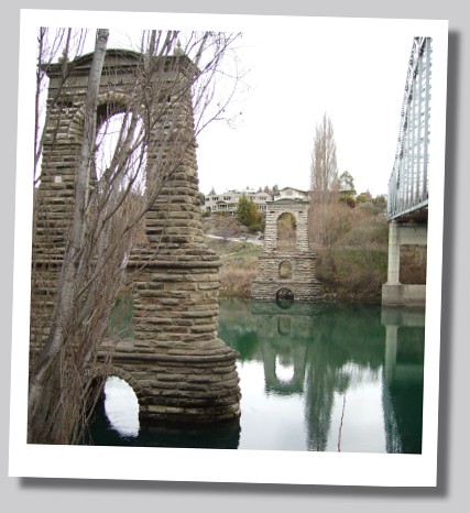 |
Dist 8.3km Total 161.2km Designed by County Engineer, L.D. Macgeorge, (who also designed the Ophir Bridge) it was the largest and most elegant of his bridges. It took three years to build and opened in June 1882. However, it was not designed to withstand motor traffic and after 70 years service, the bridge was dismantled and replaced with the present day one in 1958. Cross the bridge and take the first right to Earnscleugh Road. At 4km turn right into Marshall Road leading to dredge tailings where the Department of Conservation (Doc) has an information kiosk. |
|
Dist 4.0km Total 165.2km Earnscleugh is famed for its fruit orchards but it was gold that first lured people to the area. When the easily accessed gold was cleaned out, miners wanted access to the deeply buried gold alongside and on the beds of rivers. That led to the invention of gold dredges and the first of them started in 1898 to work the Earnscleugh Flats. Otago led the world in the development of dredges and at its peak in 1906, there were 14 dredges working between Alexandra and Clyde. The extracted gravel - the tailings - was screened for gold on the dredge before being dumped from a raised elevator. The last and biggest dredge of all, the Alexandra worked from 1933 and its closure in 1963 ending brought the dredging era to an end. Return to Earnscleugh road and turn right. At 2 Km on the left note the old barn built by a dredging company to repair machinery. Further along on the right is Conroy’s road where one the richest gold bearing gullies in the Dunstan was found and where Dawson’s established their fruit orchard about 1864. |
 |
|
Dist 6.0km Total 171.2km At the end of the unsealed road is the Packing Shed Café and Gallery. Once a large orchard, the grounds are dotted with dry stone schist walls and gardens built by owner, Lex McLean. For many years, his family mined up the Nevis Valley (access via Bannockburn) until the shaft collapsed. Lex has collected many relics from gold mining workings which are displayed in the garden. Return to Earnscleugh road and turn right to Clyde crossing the steel bridge built on the stone piers of the original bridge. |
 |
 |
Dist 4.8km Total 176.0km The township took root when thousands of gold miners poured into the area after a rich strike by Hartley and Reilly in the Clutha River in 1862. There are three museums which contain the stories and items from those days. The Railway Station, opened in 1907 is one of three that remain from Central Otago’s rail system. A separate brochure, “Walk Around Historic Clyde” guides you around the town’s historic precinct. |